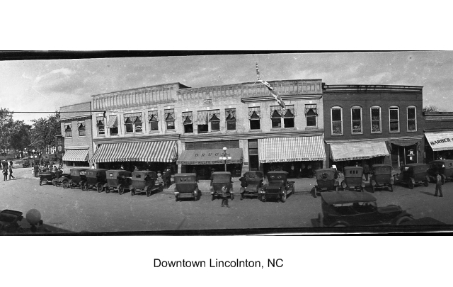
Historic Downtown Walking Tour
-
A walking tour of Historic Downtown Lincolnton
Lincoln County is situated in the southwestern portion of North Carolina's Piedmont region. The county's boundaries, encompassing 307 square miles, extend in the form of a long rectangle measuring 30 miles in length and 10 miles wide. Bordered by the Catawba River to the east, Cleveland County to the west, Gaston County to the south and Catawba County to the north, Lincoln County's landscape contains a rolling terrain full of gentle streams and creeks with natural resources that enrich the area's environment and contribute to economic development.
As early as the mid-18th century, settlers from areas of Pennsylvania, Maryland, Virginia and South Carolina, primarily of the German and Scots-Irish persuasion, flocked to this area to take advantage of the inexpensive land and rich farmland prevalent in the Carolina backcountry. Traversing the rugged terrain of the Blue Ridge Mountains and the Staunton River Gap along the "Great Philadelphia Wagon Road," these immigrants established their settlements throughout Lincoln County. On their trip, they brought traces of their native homelands in the forms of speech, behavior, religious beliefs, art and written and oral traditions.
On April 19, 1779, Lincoln County, North Carolina, named for Major General Benjamin Lincoln, commenced government. Benjamin Lincoln, originally from Massachusetts, was the commander of the Southern Department of the Continental Army and received the official British sword of surrender at Yorktown. Lincoln never visited the area and after the establishment of Lincoln County and the Revolutionary War, he went on to become the Secretary of War in 1781 and to suppress the potentially disastrous uprising known as Shay's Rebellion in 1787. The initial county was 1800 square miles and one of the biggest in the state. It included a large portion of today's Cleveland County and all of both present-day Gaston and Catawba counties. The county was partitioned in the 1840's and today Lincoln County is 307 square miles. The township of Lincolnton was established as the county seat on December 29, 1785. It was laid out with a central courthouse surrounded by a grid plan of streets, blocks and lots with four primary streets---East Main, West Main, North Aspen and South Aspen---leading from the courthouse and dividing the town into quadrants. Over time, development in Lincolnton filled the original grid plan, expanded it, and eventually moved beyond it while maintaining the four principal arteries like compass points.